Airports:
Santa Barbara
KSBA 5 Minute
Santa Paula
Camarillo
Palmdale
WJ Fox
Oxnard
Victorville
Point Magu
Santa Ynez
Santa Maria
San Luis Obispo
Palm Springs
Paso Robles
Bakersfield
Forecasts:
Forecast Discussion
Marine Forecast
Weather.com
Winds Aloft
SB Lapse Rate
El Mirage (Graph)
Salton Sea (Graph)
Soda Lake (Graph)
Santa Barbara (Graph)
Big Sur (Graph) (Text)
Observations:
VBG Balloon
Bel Air Dr
Campanil
Bel Air Knolls
Flora Vista Rd
Hendry's Beach
Hidden Westside
Cliff Drive
Mesa
Rose Cafe
More Mesa
La Cumbre OYN
La Cumbre MESO
Painted Cave Crest
Montecito 285 ft
Botanic Garden
E Camino Cielo
Gibraltar Road
Kinevan Road
Toro Canyon
Carpinteria
Harbor SB
West Bouy
East Bouy
Arguello
El Mirage
Maps & Radars:
Jet Stream
USA Wind Map
Windy Wind Map
KSBY Doppler
WeatherBug Doppler
AccuWeather Doppler
Ventura & SB Rainfall
Real-Time Rainfall
TidesChart
Webcams:
SBCC Webcam
AlertCA TV Hill
Cachuma Lake Cam
Shoreline Cafe SurfCam
Carpinteria BeachCam
101 at Bates (map)
Topanga SurfCam
Malibu SurfCam
Weather To Fly
Flying an Ultralight requires almost constant attention to the weather. Our operating limitations dictate a careful assessment of the current local weather conditions and what's on the horizon.
Here, we have assembled some of the most useful links to Forecasts and Observations as well as other interesting weather related items we like to visit.
The Java-based Skew-T or ETA Soundings are awesome tools to see winds, temps, dewpoint and more for the e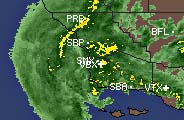 xact area you are looking to fly. Use the nearest airport code, or insert the lat/long coordinates of your favorite launch!
Winds Aloft are one of the most valuable information sources for the velocity of the air at the different altitudes, as well as the temperature difference as you ascend (better known as Lapse Rate).
Surface Wind Vectors shows a visual map view of the winds for the area, and includes a link to a 12 hour java loop of the wind, and charts for the previous 72 hours as well.
The various Satellite Loops will show you the approaching storms and their track towards the area. These take awhile to load because they are animated, but they are valuable links.
 The Doppler Radar Loop is another great animation, but you'll only use it if there's an impending storm (such as the one shown in the link picture!).
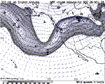
The Jet Stream analysis will give you a good idea of the general upper level flow across the area, and this will definitely affect the lower level winds if it is strong!
When given UTC (Zulu) time, just subtract 8 and you have the time of the reading. In October to March (daylight savings), subtract 7 for the correct hour.
Feel free to explore the many other links to weather, webcams and other fun stuff that we've gathered here. Please let us know if there's a good link we can add!
Other Flying Sites:
El Mirage Flying Weather
California Valley Flying Weather
Santa Barbara Condensed
(for your mobile phone)